


PATHWAYS
With so many ways to enter a career in the geospatial sector, it can be difficult to know where to start!
Explore the main pathways into the industry to help you figure out what's right for you.
What are my options?
Study for an academic or vocational degree
-
Full-time degrees take 3 - 4 years to complete
-
You can apply for higher-level jobs after graduation
-
Time spent in lectures and seminars or on individual study - or can be via distance-learning
-
Focus is on academic study
-
1000’s of courses to choose from, which could lead to careers across the geospatial industry
University
T Levels or National Courses
Blend college learning with a work-based placement
-
Courses last up to two years
-
You’ll gain a technical qualification
-
Courses are equivalent to A Levels or National Qualifications but focused on a particular industry or vocational area
-
A minimum of 45 hours is spent in industry placements
-
Choose from around 25 varied courses
College
Develop skills to prepare you for the future
-
Course lengths vary - from weeks to years!
-
Gain further education and build technical, vocational or academic skills
-
Study for T Levels, NVQs, City and Guilds, Higher National Diplomas, BTECs, A-Levels, GCSEs, or National Qualifications
-
Prepare for a specific career path or higher level qualifications
Apprenticeships
Earn a wage whilst learning a specific job
-
Take 1 - 5 years to complete
-
Time split between your employer and a training provider
-
Over 100 roles can be entered through apprenticeships, with more being added
-
Earn as you learn
Traineeships
Get ready for the world of work
-
Can last anywhere from 2 weeks to 6 months
-
Prepare 16-24 year olds for work or an apprenticeship
-
Provide hands-on work experience and support with preparing CVs and applying for jobs
-
Boost literacy and numeracy skills
Work Experience
Gain industry insight and skills for your CV
-
No limit to how long or short it can be
-
Opportunity to pick up skills for your CV
-
Chance to gain industry connections
-
May be advertised by an employer, or you can arrange a placement yourself
-
No costs involved
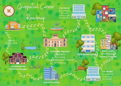
Geospatial Career Roadmap
Scroll to find your exam and see your roadmap!
Roadmap for:
-
National Qualifications
-
Highers
-
Advanced Highers
Where can I study?
A degree or equivalent is always desirable, but for some roles it's essential.
There are many degrees which may help you enter the geospatial engineering sector.
If you have a specific role in mind, such as GIS analyst or land surveyor, you could look at the universities which offer courses in your chosen field.

GIS Technician
Manages GIS data, including digitising, collecting data, analysing, and creating maps to support intelligent decision making for instance for urban or transport planning
£25,000 - £30,000

GIS Technician
Manages GIS data, including digitising, collecting data, analysing, and creating maps to support intelligent decision making for instance for urban or transport planning
£25,000 - £30,000
Geospatial degrees in the UK & Ireland
Click on the map locations or scroll through the options on the left to find out what geospatial degrees are on offer in the UK and Ireland.
Geospatial College & University Programmes
Click on the map locations or scroll through the options on the right to find out what geospatial degrees are on offer in the UK and Ireland.
Featured Programme: Fife College Geospatial Foundation Skills Programme
Fife College is the only Further Education provider in the UK which offers a geospatial course. Designed both for school-leavers and those looking for a career change into geospatial, this 18-week Geospatial Foundation Skills course is formally recognised on the Scottish Credit and Qualifications Framework at SCQF Level 6.
The course covers geospatial data concepts and principles, software and analysis tools, making effective maps, the fundamentals of earth observation and satellite technology, and geospatial applications. Students will gain an understanding of geospatial data in the context of societies and policy formation, including climate change and sustainable development. Students are introduced to the concepts of project management and are connected with a professional in the geospatial field to undertake a project with real world impact.
The innovative collaboration, which includes Location Data Scotland, the Association for Geographic Information in Scotland and the University of Edinburgh won the prestigious AGI Award for Geospatial Collaboration and Partnership in 2025.
GIS Technician
Manages GIS data, including digitising, collecting data, analysing, and creating maps to support intelligent decision making for instance for urban or transport planning
£25,000 - £30,000

GIS Technician
Manages GIS data, including digitising, collecting data, analysing, and creating maps to support intelligent decision making for instance for urban or transport planning
£25,000 - £30,000

Praise for Fife College Geospatial Foundation Skills Programme
“This project is a prime example of the growing innovation at the heart of our college sector. It will help ensure that we have the skills and talent to match the rapidly expanding and evolving digital and green economies." -- Richard Lochhead, Scottish Business Minister
"This is a remarkable collaboration which will bring new talent into the geospatial workforce in Scotland, supporting existing organisations, allowing new businesses to develop and promoting inward investment." -- Bruce Gittings, Chair of AGI Scotland
Working from the whole to the part, Geospatial Surveying investigates the extraordinary geography associated with our planet.
Emily
Geospatial Mapping and Surveying Student at Newcastle University

Find out more about Studying at University

Get qualified!
The Survey School is home to the TSA Surveying Course, which is designed for new entrants into the Geomatics industry, or those with experience but no formal training.
It is intended to broaden the student’s practical experience and to supplement the theoretical experience gained from their employer.
The Survey School offer a number of short courses too, ranging from 2-5 days, with discounts for CICES and TSA members.